
The California Pilots Association (CALPILOTS) recognizes the requirement to provide housing and employment for people with developmental disabilities. The issue with this proposal is the location of this large facility (directly across from the beginning of runway 30 at Half Moon Bay airport – see graphic), with one building of up to five stories in the proposed business park.
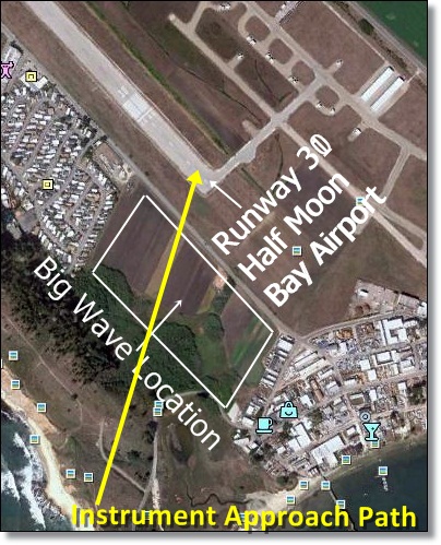 The proposed Big Wave project in Half Moon Bay, located next to, and inside of the Half Moon Bay Airport Influence Area, is an ill-conceived plan to build numerous structures within the safety zones of Half Moon Bay Airport.
There is a reason that both the FAA and Caltrans Division of Aeronautics require safety zones located adjacent to the state’s airports operational area. It is to mitigate the inevitable safety and noise issues associated with airports.
Interestingly, and as a side note, so far the San Mateo County Airport Land Use Commission is being ignored in the planning process. It is difficult for CALPILOTS to understand why this valuable asset, whose function is to review development compatibility with the airport, is being ignored.
Why should the ALUC be involved? Their role is to objectively review all proposed development projects in the airport operational area to insure that there are no long term safety hazard and noise issues associated with the project. This is especially important since approximately 75% of aviation incidents, and accidents are experienced on takeoff and landing. To help illustrate this point, this drawing was taken directly from the California Airport Land Use Planning Handbook – the drawing is a composite of actual runway arrival and departure mishaps, incidents and accidents on a 4,000’-4,999’ runway – note runway location in the middle of the page.
It is also telling that when investigating this project online, CALPILOTS had to work very hard to obtain a diagram (a very fuzzy black and white picture in this case) of the proposed project’s location. It should be readily available, and for some reason it is not – until now.
The following information has been provided to San Mateo County Planning Commissioners to assist them in their understanding of the issues and liabilities associated with this decision.
San Mateo County Planning Commissioners
November 17th, 2010 –
Re: Summary of Issues associated with the location of the Big Wave: Wellness Center, Office Park, and Associated Land Uses adjacent to Half Moon Bay Airport.
1. Failure to Comply with CEQA Requirements
CEQA, or the California Environmental Quality Act, is a statute that requires state and local agencies to identify the significant environmental impacts of their actions and to avoid or mitigate those impacts, if feasible.
a) The staff report cites the California Airport Land Use Planning Handbook (the Handbook) as a controlling document to be complied with in regards to maintaining Public Safety near airports. We disagree it was used based upon the following information which hasn’t been considered to date.
b) There are two Instrument Approaches to the Half Moon Bay Airport (HAF), which are attached:
i) A “Straight In” RNAV (GPS) Z RWY 30 approach to the end of the runway adjacent to the proposed site that has aircraft descending to 309 feet above the area before the pilot sees the runway.
ii) A “Circle to Land” RNAV(GPS) Y RWY 30 approach that is rotated 17 degrees over the property to the South that allows aircraft to maneuver within 1 mile of the runway at 734 feet above the area.
c) The Handbook addresses the following Public Safety “Guidance” for Land Uses in these areas as:
i) Zone-2, Inner Approach/Departure Zone, 200 to 400 feet above the runway/ground:
* Prohibit children’s schools, day care centers, hospitals, nursing homes
* shopping centers, most eating establishments, theaters, meeting halls, multi-story office buildings, and labor-intensive manufacturing plants {are} unacceptable
* Prohibit residential uses except on large, agricultural parcels
* Prohibit hazardous uses (e.g. above ground bulk fuel storage)
ii) Zone-3, Inner Turning Zone, 400 feet up to the 800 to 1,000 foot Visual Traffic Pattern.
* Prohibit children’s schools, day care centers, hospitals, nursing homes
* Avoid… major shopping centers, fast food restaurants, theaters, meeting halls, buildings with more than three aboveground habitable floors
* Limit residential uses to very low densities (if not deemed unacceptable because of noise)
* Prohibit hazardous uses (e.g. above ground bulk fuel storage)
iii) Zone- 5, Sideline Zone, close-in area lateral to the runway.
* Avoid children’s schools, large day care centers, hospitals, nursing homes
* Avoid residential uses unless airport related
2. Additional Sensitive Use limitations in “the Handbook, “requiring special protection from hazards”
* “Low Effective Mobility Occupancies: Society normally seeks a high degree of protection for certain groups of people, especially children and the infirm. A common element among these groups is inability— either because of inexperience or physical limitations—to move out of harm’s way. Among the types of land uses which are regarded as particularly risk sensitive are elementary and secondary schools, day care centers, hospitals, and nursing homes.”
* California Education Code 17215 directs School Districts to use special processing and evaluation by the Department of Transportation “if the proposed site is within two miles, measured by air line, of that point on an airport runway or a potential runway included in an airport master plan that is nearest to the site.” The Wellness Center project should receive a similar degree of scrutiny.
3. State Level Public Safety and Airport Protection Guidance
* 21670. (a) The Legislature hereby finds and declares that:
(1) It is in the public interest to provide for the orderly development of each public use airport in this state and the area surrounding these airports so as to promote the overall goals and objectives of the California airport noise standards adopted pursuant to Section 21669 and to prevent the creation of new noise and safety problems.
(2) It is the purpose of this article to protect public health, safety, and welfare by ensuring the orderly expansion of airports and the adoption of land use measures that minimize the public’s exposure to excessive noise and safety hazards within areas around public airports to the extent that these areas are not already devoted to incompatible uses.
* Senate Bill 1350 (Rainey) Chapter 506, Statutes of 2000—Added Section 21670(f) clarifying that special districts are among the local agencies to which airport land use planning laws are intended to apply.
Conclusion
Based upon the information above, it is clear that staff planners have not used the guidance of the California Airport Land Use Planning Handbook, or the Airport Land Use Commission (ALUC), regarding this project. To insure public safety this omission must be changed. The likely outcome of an ALUC review, in accordance with current Safety Considerations for Land Use Planning within 2-miles of Public Use Airports, is that an appropriate site for the proposed land uses would be beyond 2-miles from the airport – outside of the Airport Influence Area.
Note: To read the Division of Aeronautics response to the project click on the attachment below.