
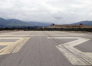
 An important issue for flight safety has arisen at the REI airport in Redlands, CA. Dirt for a water project is being piled within the #1 (A) Zone which requires a 20:1 safety limit and is located south just off the centerline for runway 26. The height of the pile (last measured by GPS) a few weeks ago is 79 ft. above the landing zone for 26. Another 13 ft. is to be added under an excavation project for a water holding pond east of the runway. The distance from the runway is about 800-900 feet. Coordinates are W 117.5.100 and N 34.5.100
The total height of the lift will become 92 ft. above the runway. In all calculations, the slope of the terrain east rises up and not level data reference. The rise places the lift some 39 ft. into the clearway. In the landing pattern, on approach, the wingtip is about level to the top of the pile of dirt. Permitting has not taken place with the company under contract and the County of San Bernardino seems to be behind schedule in securing the safety aircraft.
Also, the helicopter pattern is at an AFL altitude of 500 ft. to the south of the airport and passed over the mound. This places the helos only approximately 400 feet above the mound.
Any night flight is settable of impacting the mound as it is unlit and a danger if the pilot is not aware of the mound. The City of Redlands Airport person is trying to resolved the issue, but is new to the job. As the past Chairperson for the Airport Advisory Board, the subject was brought up many times and management couldn’t get answers either from the County or the Project Contractors.