
At which Southern California airport can you walk right up to planes, visit a nature garden, see a vintage hangar, go on a 2-mile hike and afterward enjoy a bison burger, while taking in a panoramic view of the ocean?
 Well, it’s certainly not LAX. And it’s not Ontario, Burbank or John Wayne. It’s AVX – Airport in the Sky on Catalina Island. The tiny airport can be reached via bus shuttle from Two Harbors or Avalon, and it is one of the more enjoyable excursions on the island.
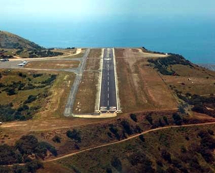
Located at 1,602 feet above sea level, the airport sits at one of the highest accessible points on the island, allowing for a panoramic view. You can get up close and personal with Cessna’s on the runway; you can see whale bones at the nature center, you can eat at the DC3 Café and you can take a nice, relaxing stroll on the Airport Loop Trail. The airport is located at the approximate mid point of the Trans-Catalina Trail, so hikers who want to get a feel for the island’s rugged back country can use AVX as a starting point. Blackjack Mountain, the island’s highest accessible summit, lies 2.5 miles south; five miles to the west, scenic Little Harbor makes for an ambitious destination.
Catalina Island is often touted as a perfect escape from the hectic pace of L.A. life. The airport itself – with no security lines, no disgruntled employees at the counter and no exorbitant parking or luggage fees – is in keeping with that spirit. For most people, airports are necessary evils to endure in order to enjoy a vacation. But with AVX, the airport is the vacation.
For more information, check out the site for the Airport in the Sky. You can find out more about the Airport Loop Trail here and more about the hike to Little Harbor here. There’s also this hike to Blackjack Mountain.